Discovering and mapping the lost trails and history of Acadia
This site contains GPS data collected in the field using historic trail maps, guides and years of hiking in Acadia National Park — first published as GPS Acadia, now rebuilt as a field atlas.
How the trails were found
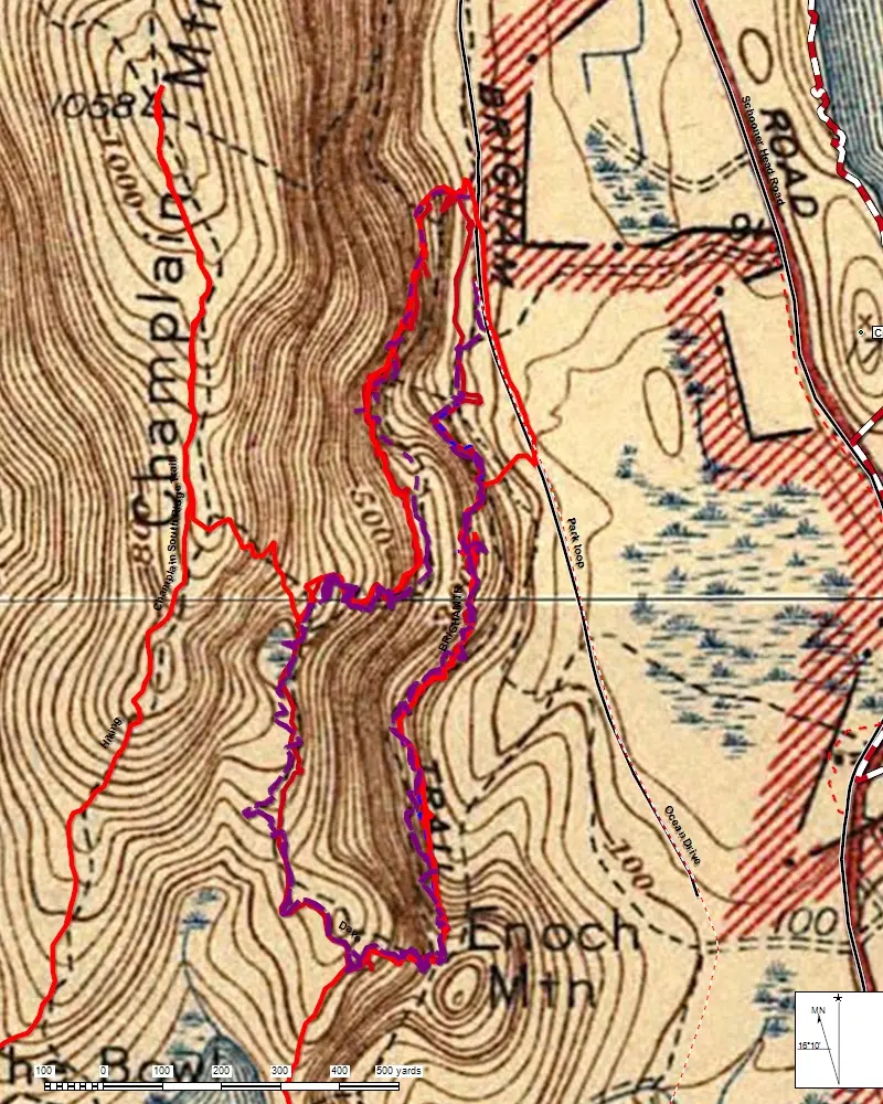
Each search starts on paper: a line on a Bates, Rand and Jaques path map, a sentence in an 1880s guidebook, a dashed trail on the 1942 USGS sheet. Then comes the walking — a handheld Garmin recording a track while every cairn, step, junction, cellar hole and blaze gets a waypoint and a written note.
Back home the tracks are cleaned and labeled in ExpertGPS, named from the historic sources (following Pathmakers names and numbers where they exist) and filed by area in the “My Maps” archive. This site reads those curated files directly: all 923 readable GPX files in the archive, with repeated copies of the same track or waypoint merged so each appears once (a track counts as a repeat when 85 percent of it retraces one already on the map). A statewide place-name database kept with the field files, and a handful of points far outside the region, are left out. Each track keeps a note of the file and folder it came from, and photos taken within 30 meters of a waypoint appear in that waypoint’s note.
The Library’s research archive holds the write-ups, deed abstracts, surveys, clippings and map scans gathered for each area along the way.
Fitting the 1942 map to the ground
The Library of Congress scan of the 1942 sheet (10,470 × 11,366 pixels) has no coordinates of its own. To lay it under modern GPS tracks:
- The map’s own legend gives its projection: polyconic, 1927 North American Datum, scale 1:31,680.
- 34 control points were measured where the printed 2½-minute graticule crosses fall, plus tick marks along the neatline from 44°12′30″ to 44°27′30″ N.
- A third-order polynomial fit absorbs the paper’s shrinkage and fold distortion. Root-mean-square error is about 2 pixels — roughly 11 meters on the ground.
- Coordinates are shifted from NAD 27 to WGS 84 with the National Geodetic Survey’s NADCON grid (accurate to well under a meter; the shift is about 40 m in this part of Maine). The sheet is then cut into web-map tiles from zoom 10 to 15. The Schoodic inset is masked out.
Checked against the 15-minute quadrangles
The same 1930s survey was also published at 1:62,500 as the 1942 USGS Mount Desert and Bar Harbor 15-minute quadrangles, which the USGS distributes already georeferenced. Comparing the two fits by image matching in 387 windows across the island:
- The two agree to a median of about 17 meters, with almost no overall shift (about 5 m).
- Measured against modern USGS shorelines and pond edges, this site’s fit is as close as the quadrangle’s or slightly closer (median about 30 m versus 36 m on the same windows).
In the Atlas, the 1942 map menu can also show these quadrangles, either alone or around the edges of the Acadia sheet. That fills in Schoodic, Trenton, Lamoine, Gouldsboro and Swans Island, which the park sheet leaves out or shows only as an inset. The larger sheet stays the default base map: it has twice the detail, and its fit is at least as accurate. The remaining differences come mostly from the 1930s survey itself. Old woods roads and footpaths were mapped by plane table, so expect the printed line and the trail on the ground to differ by a few tens of meters in places. Your GPS track is the better guide to where a path actually runs.
What the line styles mean
East and West
Somes Sound is the dividing line. Each track is assigned to the side where its midpoint falls; each waypoint to the side where it lies. Anything whose midpoint lies off Mount Desert Island (Schoodic, Trenton, Blue Hill, Deer Isle, the Frenchman Bay shore and the outer islands) is filed under Off-Island. The island outline used for this test is from OpenStreetMap.
Walk lightly
Acadia’s Hiking Trails Management Plan defines abandoned trails as those the park “no longer maps, marks, maintains, or advertises for public use,” and notes that maintaining abandoned trails or building unauthorized ones is actively discouraged. The park asks visitors to walk only on designated trails and durable surfaces, and not to stack rocks or alter cairns. The request is an old one: the 1915 Path Guide asked that the island’s signs, rustic arrows and cairns not “be altered in any way.”
- Use this atlas to understand the landscape, and to read the old guides with fresh eyes.
- Check current alerts and closures, including seasonal peregrine falcon closures on cliff trails.
- If you find a cultural artifact, leave it in place, photograph it, note the location and tell a ranger, as the park requests.
- Many historic paths run through private land. Field notes flag posted property where it was seen; treat every unmarked route the same way.
Use at your own risk
The routes on this site are historic and unmaintained. Many are not official trails, and the lines shown may be tens of meters off the path on the ground. They can lead into swamps, across talus fields, into caves and onto private land. You alone are responsible for your safety and for staying on legal routes. I accept no responsibility for any injury, loss or harm from using this site. Don’t hike alone, and always leave your route and return time with someone.
Credits
Field data, tracks and notes © 1994–2026 Les Heilakka, with hiking partners credited in the original files. Base map: U.S. Geological Survey, 1942, scan from the Library of Congress Geography and Map Division (public domain). Modern topography and imagery: USGS The National Map. Mapping library: Leaflet. Every guidebook, map, study and web source behind the site is listed on the Sources page.
This website was designed and built, and its GPS files, photos and archive documents organized, with the help of Perplexity Computer, an AI assistant. All fieldwork, tracks, field notes, photographs and historical research are my own, and I reviewed everything published here.
This site is not associated with the United States Government, the Department of the Interior or the National Park Service. Questions and corrections are welcome at info@losttrailsofacadia.com (write in Gmail).